|
Wednesday, Sept. 7, 2011 – On the Road
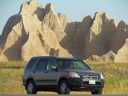
Got the car packed and left at 7:00. We made our way through I-15 traffic in Southern California. We arrived in Vegas as scheduled for a lunch stop at “In and Out Burger” off Tropicana Way. The freeways are always torn up in Vegas so we had to do a little detour through town. You can do a lot of people watching while waiting for one red light to turn green. “In and Out” was “In and Out.” We gobbled down a #3 and were back on the road in no time.
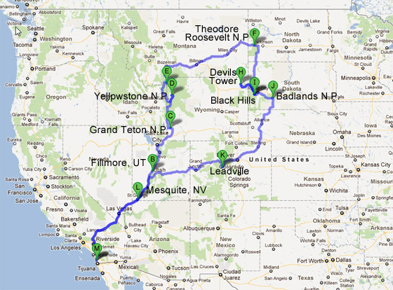
We passed the time by listening to an audio book “The Last Stand: Custer, Sitting Bull, and the Battle of the Little Bighorn”. It’s interesting, but goes into so much detail – probably wouldn't be so fascinated if we weren’t headed into Custer country.
We made a couple of gas and pee stops. The country gets amazingly beautiful just north of Vegas. We arrived at our Best Western in Fillmore, Utah. Bill checked his email while I took a stroll into town – can’t really see these little places unless you’re on foot.
I came back to the room, waited for Junior Theatre to post the audition results for their upcoming production of “Annie.” Zion, our granddaughter, was cast as ANNIE. We were shocked and so excited. We called Zion. She was crying too. Man, what a kid and what an opportunity!
We had dinner at the Best Western restaurant. I had BLT, Bill a turkey sandwich and soup. All we talked about was our little star Zion. It’s a good thing we won’t be in San Diego again for almost 4 weeks. We’ve both become even more insufferable grandparents.
Thursday, Sept. 8, 2011 – Grand Teton National Park
Didn’t sleep well last night – kept thinking about my Zion up on that big stage belting out “The Sun Will Come Out Tomorrow” in her upcoming role as Annie.
We had breakfast at the Best Western Paradise Inn Restaurant in Fillmore Utah. I had bacon and eggs. A hot breakfast came with the room – nice. We left Fillmore (and the Best Western) about 7:30. Bill couldn’t get gas because the town’s electricity was out, leaving no credit card transactions and no service.
We listened to more of the “The Last Stand” audio book. I really hate George Armstrong Custer.
The scenery was beautiful; the day is lovely . . . then came the road construction. I think they’re redoing all the highways in Utah – glad somebody has funds. We did have a couple of little hiccups with navigation. The GPS gal (who has been lovely so far on this trip) mapped out a different route around Salt Lake City than Bill’s Goggle map printout. I had to be “the decider.” The GPS directions to Fossil Butte National monument on the way to the Grand Teton also didn’t jive with Goggle. I don’t like to be the decider, so we skipped Fossil Butte and went on to our destination for the day – Grand Teton National Park.
The scenery was getting nicer and nicer when, all of a sudden, a warning light came on the dashboard. We stopped at an auto shop in a little town and had a nice mechanic tap into our car computer. He said his generic code finder showed a problem with the CO2 indicator. He reset the code and said we had to take it to a Honda Dealer to get the real scoop. It was nice to have the light off and worries suspended for a while. We stopped at Blondie’s Café in Cokeville and had a Senior’s “Out to Pasture” lunch – more burgers and fries. And to think I’m a heart patient!
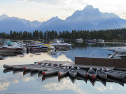
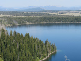
We made another stop in Jackson for gas – cute town, but completely swamped with crowds. Jackson (the city, the Hole, and the lake) were named after Dick Jackson, a noted fur trapper – mostly beavers, I believe.
After we left Jackson, the drive along the Snake River up into the Grand Teton National Park was breathtaking. The Grand Teton was named by some French fur traders. Teton means “tit” in French. Those French guys most have been very lonely when they named the Grand Teton.
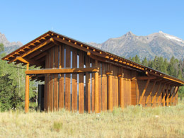
We went to the new Visitor’s Center in Moose – beautiful with a very fine orientation video. After the video finished, the curtains in the theater opened to a view of the Tetons – nice touch.
 |
|
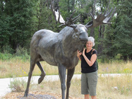
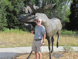
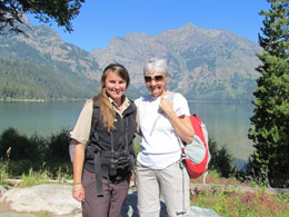
| Bill and Nancy Outside the Visitor’s Center in Moose |
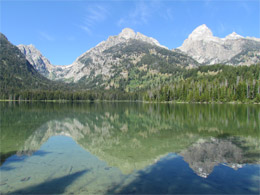
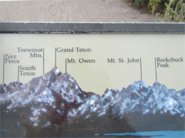
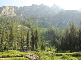
| The Teton mountain range, about 13,000 feet high, was formed underground. The mountains are only 8 million years old, which is geologically young. Earthquakes were the instigator causing rubbing action between a couple of plates. After a while, one plate shot up forming the spikey rocky structure while the other plate sunk deeper into the earth. The landscape is still changing – and experts say another big earthquake about magnitude 7 is due any day. You could really see the distinct rocky ridges (on the upper plate) juxtaposed with the deep valley of trees (lower plate). |
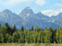
The Grand Tetons |
After the Visitors Center, we checked a few things off our list in the Moose area. The last tour bus of the day was just pulling out of the empty parking lot as we drove in. The area is called Menors Ferry. Bill Menor and his brother, Holiday, were part of the community in the early 1900s. Bill Menor had a reputation for swearing and he liked to say, My partners mean, but Im Menor. They ran the ferry, loading up people and their belongings to pull them across the swift river for a fee, of course. The ferry was right next to a general store that the brothers ran. They painted the building with whitewash from Holidays lime kiln. The park did a great job of restoring Menors General Store. We explored Maude Nobles cabin, where the idea of the Grand Teton National Park was conceived. There was also the Chapel of the Transfiguration (Episcopalian) nearby to bring religion to the place. As I was nosing around the church, Bill rang a bell which further deafened me now that was Mean and not so funny to a person is already half deaf to begin with.
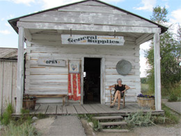
Menors General Store |
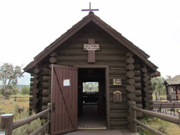
Chapel of the Transfiguration |
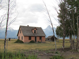
We got back into the car and headed to Mormon Row to check out some of the old houses and barns left behind. Some still remain private property. A group of 5 Mormon families came out in 1889 to try and make a go of it. Many moved on and left their barns and houses standing vacant. Some folks stayed on their property here in the park. They continue to own the land as private property until they die, then the deed goes to the National Park. (Some grannies and grandpas are still hanging on.)
Mormon Row |
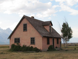
Mormon Row |
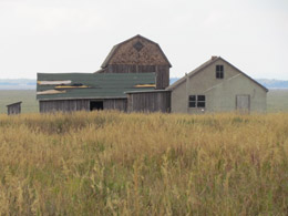
Mormon Row |
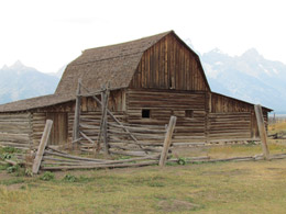
Mormon Row |
I got some nice shots of the old homesteads and barns overgrown with sage brush. I really like my fancy new camera.
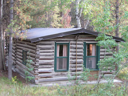
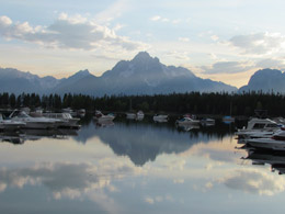
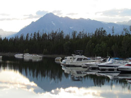
We drove to our cabin in Colter Bay Village. The place is named after John Colter, who was the first white man to discover the Teton Mountain and upper Yellowstone. He was an experienced hunter on the Lewis and Clark expedition of 18041806. After the expedition, he stayed in this area for another year and became a fur trapper. Quite some guy! More stories about him later.
Our Colter Bay Village Cabin |
Colter Bay |
We checked in at the small lodge office (which was once a gas station in the 1920’s). We researched Honda dealerships on the internet to have someone check our warning light – none nearby. We’re in trouble. We settled in and had a beer and tried to forget all the “what if” car scenarios. Maybe it wasn’t smart taking a car with 100,000 miles on a road trip. We went to dinner at the restaurant in Colter Bay Village. The portions were huge. I had salmon, Bill the meatloaf wrapped in bacon – more bacon!
We waddled back to the room, did some journaling when I listened to some silly, giggly Indian (Asian) gal in the cabin next door yammering on and on. I’m currently debating whether I should bang on the wall or perform some other passive aggressive act.
NOTE: All is well that ends well – At 10 pm, Bill put on his pants to go next door, but the gal ended her conversation and was quiet as a mouse all through the night.
Warning lights, noisy neighbors, all part of life on the road.
Friday, Sept. 9, 2011– Grand Teton National Park
It was cold in the cabin. I didn’t sleep well, plus we only have a double bed and a single bed. We snuggled until 7:00. Our Indian neighbors were up and gone by 6:30.
We had a terrific breakfast, organic oatmeal and fruit and toast, at the lodge served by a charming waitress from Macedonia who is studying to become a dentist. We stopped by the store for some beer (running low) and then went back to the cabin to pack our lunch and get ready for our hike today.
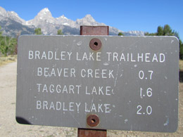
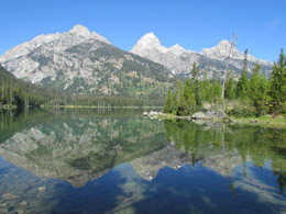
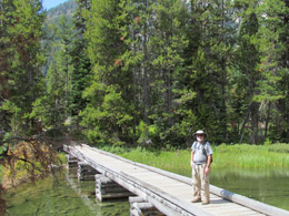
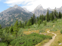
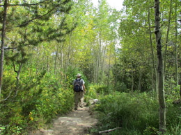
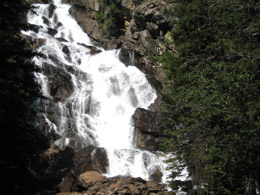
We hiked to Taggart Lake, Bradley Lake and Beaver Lake – about 6.5 miles. Perfect temperature, amazing views of the Tetons and oh so good to be moving our old bodies again. Two long days of driving trapped in the car with nothing but a diet of burgers, fries and bacon will get to you after a while.
The Taggart Lake Trail went through quaking aspens, lodgepole pines (thick as dog hair as described in the book) and by the shoreline of gorgeous lakes. Taggart and Bradley were part of the 1871 U.S. Territorial Survey Expedition with Hayden and ended up getting some beautiful lakes named after them. We came upon Taggart Lake first – it was much larger than Bradley’s lake.
Trail Head |
Taggart Lake |
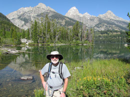
Bill at Taggart Lake |
Taggart Lake |
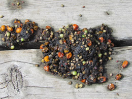
We had lunch at Bradley Lake and then walked along the shore and crossed a bridge. Right in the middle of the bridge was a pile of fresh bear scat. You could see what the bear had for breakfast that morning. We decided to turn back and head to Beaver Lake – although we didn’t know what direction the bear was going when he stopped to do a dump.
Bridge over Bradley Lake |
Bear Scat |
Taggart/Bradley Lake Trail |
Taggart/Bradley Lake Trail |
Most of the other hikers on the trail had a can of bear spray within easy reach – a reaction to the 2 recent bear-killing-hikers episodes that played themselves out in this area. Bill left bear spray behind in the car. We spend a lot of time talking about how the spray wouldn’t do us any good anyway if, per chance, we stumbled across a bear. Wish I had a piece of the bear spray business. One guy, hiking alone, wore bells on his ankles. The jingle-jangle ruined the atmosphere. In spite of the fear of bears, everyone on the trail seemed happy. Most were old retired farts like us – who wouldn’t be happy about that.
On the way to our next stop, the warning light on the dash went off. Good news – maybe the problem fixed itself; or bad news – maybe the light burnt out. Go figure. We’ll take it as good news.
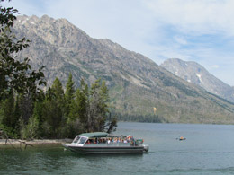
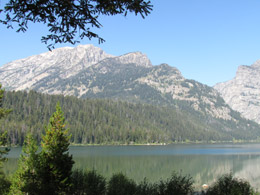
We stopped at Jenny Lake, the Grand Teton’s first visitor area. Since the early 1900’s, visitors came to Jenny Lake to hike, swim and take pictures. Before the visitors came, there was the famous Hayden’s mapping party, who, by the way, named Jenny Lake. Jenny was the wife of one of Hayden’s guides, Beaver Dick Leigh (who got his own lake named after him – Leigh Lake). It seemed that everyone on the expedition loved Jenny. She cooked and took care of them. She was Indian and had six children. Her husband, Beaver Dick, really loved her. Some years after the expedition she and all of their six children died of small pox. Beaver Dick, being a WASP, with more immunities to small pox, survived, but he was heartbroken. A few years later he married another Indian squaw named Tadpole (either Sue Tadpole or Sioux Tadpole) and they had three children. She didn’t look as happy as Jenny in her photos.
Jenny Lake |
Boat Dock at Jenny Lake
|
At Jenny Lake, we checked out the ferry for tomorrow’s hike and stopped in at the Visitor’s Center. The building for the Visitor’s Center was “re-purposed.” It was constructed in 1925 near String Lake as a photo store and art gallery by artist Harrison Crandall. It was then moved to Jenny Lake to become the Visitor’s Center. I talked to a ranger who didn’t know much about Jenny and Beaver Dick and the history of this place, but she was very accommodating and pulled out a fascinating book of old photos to share with me. I got to see several shots of Jenny and Beaver Dick and their gang.
After Jenny Lake, we drove up to Signal Mountain with yet another breathtaking view of the vast flat lands. This vast “valley” in the mountains edged by the mountain ranges is referred to as a “hole” – thus the name “Jackson Hole.” We looked across the “hole” and saw what looked like a forest fire with its billowing clouds in the far distance.
Sign on Signal Mountain |
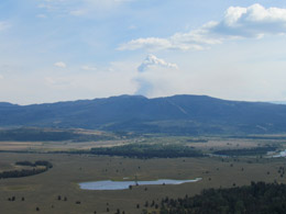
Jackson Hole with fire in the distance |
At Signal Mountain, we learned about William Henry Jackson (1843-1942), the photographer on Hayden’s expedition in 1871 (U.S. Territorial Survey Expedition). William Henry Jackson was the first to photograph the Teton Range. Jackson and his assistant climbed Signal Mountain (and other mountains) lugging heavy cameras, glass plates and dark room equipment to shot and develop the film on the spot. The Hayden Survey Report, with Jackson’s photographs, convinced Congress to make Yellowstone the first national park in 1872. By the way, the place “Jackson” and “Jackson Hole” are NOT named after the photographer – but rather after a noted fur trapper, Dick Jackson,
My life as a modern photographer is so easy. We drive to the top of the mountain and snap away with my wonderful new camera that can go from the widest of angles to the zoomiest of zooms (35X optical zoom). I have to make myself put the camera away to drink in the views without a view finder limiting my experience. On Signal Mountain, I snapped a few photos – far more than Bill could tolerate and then we drove back to the cabin for a beer and a shower.
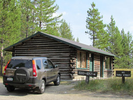
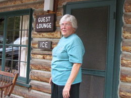
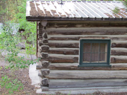
At 5 pm, we went to a talk about the cabins here in Colter Bay Village given by Mary McKinney, a woman from Augusta, Georgia who really knows her stuff. Colter Bay Village is actually an eclectic collection of cabins from various sites around Jackson Hole. We’re staying in one of these charming old cabins.
John D. Rockefeller, Jr. came out to visit the Grand Teton in 1926. He loved its beauty, but was sickened by all the crumbling cabins and barns and buildings and other schlock in the valley. He began buying up the land (schlock and all) to save it for future generations. He tried for years to donate the land to the U.S. government to establish a National Park. Congress didn’t want it so he threatened to sell the land and let development conquer the natural beauty. Finally, in 1950, after much wrangling, Rockefeller’s donation of 34,000 acres was accepted and the park was established and guest accommodations were badly needed. So in 1957, J.D. Rockefeller transplanted the crumbling cabins (left over from old resorts, old dude ranches and old homesteads in the area) to Colter Bay as lodging. Many of the cabins were constructed in the 1920’s and 1930’s, but some date back to the late 1800’s. Rockefeller hired an architect to artfully place the cabins within the woods. Mary said the architect’s wife wanted the cabins placed together. Because of this, a few were lined up side by side, which is not how they would have been originally built. As times changed, electricity and bathrooms were added to each cabin.
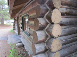
Our guide, Mary, took us around to some of the cabins. She told us fascinating stories about the history, the people, how they were made and where they came from. She told us how the cracks between the logs were stuffed with old newspapers, letters, old underwear or anything else available and then covered with mud. This is called "chinking". Oh the treasures that lie within those logs! One of the more anal pioneer wives scrubbed all the mud out from the walls leaving the howling winds and cold winter snow pouring through the walls. One of the cabins was moved for a movie set where John Wayne had his very first role. Another cabin was built by a lazy drunk (Lowell) and the logs were thrown up in a drunken stupor. Our cabin (#1003) was once a part of the Circle H Ranch right down by Moose Wilson road. Before Mary’s talk, we didn’t pay much attention to this amazing collection of history we get to stay in.
Mary, the Expert on Teton History |
Log Cabin Detail |
Colter Bay Village Cabin |
Colter Bay Village Cabin |
We went to dinner at the lodge. I had the endless soup and salad only to find the salad bar line was SLOW. It takes hours for old farts to use those tongs and load up their plates.
We walked down to Colter Bay as the sun was setting. It is so beautiful here.
Colter Bay |
Colter Bay |
We called the family. Amy, Brian and Zion were at Dave and Buster’s celebrating Zion’s role in “Annie”. There’s a whole lotta excitement back home.
Life is looking up – not a peep from next door and the Honda’s warning light is off.
Saturday, Sept. 10, 2011 – Grand Teton National Park
Wonderful full day – perfect weather – started out cold, but turned into a great day with highs in the mid 70’s.
We had breakfast at the lodge at 6:30, opening time. We were disappointed that the oatmeal wouldn’t be ready until 8 o’clock, but hey, traveling can be a bitch sometime.
After breakfast we went to the Indian Museum in the Colter Bay Visitor’s Center. Some generous person gave his collection of Indian stuff and what a collection it was – weapons, peace pipes, clothing, baskets, silver pieces, head gear and lots of beaded work. I was taken by the 50 or so pair of moccasins, all unique and all showing very little wear. I was also struck by the beadwork on bags and pouches, many with designs taken from the Western Europeans. The Indians used these designs to sell souvenirs to whites passing through. A lot of the treasures used glass beads made in Italy. The beads were shiny and cheap and used by the whites to trade for real goods, such as beaver skins and land. Not a bad deal, if you’re white and know how to get cheap beads from Europe.
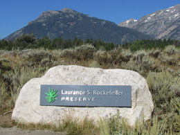
After the museum, we drove 30 miles to Moose, at the south entrance of the park, and then to Moose Wilson Road (which connects the towns of Moose and Wilson). Laurence P. Rockefeller came to summer in these parts with his dad, John D. Rockefeller and 3 brothers. In the 1920’s, Laurence bought a huge hunk of land right on Phelps Lake from a guy who had several ex-wives and was in financial trouble. Laurence turned it into his family getaway, building a huge house, barn, stables, swimming pool and 30 other buildings. Laurence loved it here and when he got old, he decided to give the land to the people. He wanted folks to enjoy the beauty of the place when he first came here – so he removed all the roads and structures, including the main house and barn. He then constructed the most unusual Visitor’s Center – very sparse and very modern and NO GIFT SHOPS! He added some trails and a parking lot that has only 30 spaces. When the spaces are gone, the 31st car must wait until another car leaves – clever way to keep the traffic down.
We arrived right at 9 am – opening time and took the 6th parking space. We walked to the back of the Visitor’s Center and joined a ranger-led hike to Lake Phelps. The group was of the retired vintage from all over the country – so the hike took much longer. Megan, the rangerette, was adorable. She was so positive and excited about her summer job, working here at the Laurence P. Rockefeller Preserve. She is a ranger, although she wasn’t wearing her regulation hat. What she lacked in knowledge, she more than made up for in perkiness. She charmed us all. She just graduated from college in environmental studies and landed a job 3 weeks later. She lived in Salt Lake City and as a kid and spent summers in the Tetons. When she was a teen, she and her pals tried to sneak into the Rockefellers’ swimming pool, but were chased off the property. She and her friends spent a lot of time swimming in Lake Phelps and diving off a huge rock that juts up from the lake.
Laurence Rockefeller Reserve |
Laurence Rockefeller Reserve |
Random thoughts from Megan’s talk:
- Forest fires are needed – they melt the resin in the pine cones to seed fresh trees.
- The white beetle is killing the trees. The pest is harder to eradicate because of global warming. It has a longer time to develop in the trees. This protects it from its predators.
- Valleys that are V-shaped are carved by flowing water. Valleys that are U-shaped are carved by moving glaciers. Megan demonstrated how glaciers carve landscapes by scrapping her foot in the dirt. The front of her shoe represented the terminal lobe of the glacier when the sides of her shoe represented the lateral lobe. The displaced dirt is the valley. The glacier melts and leaves behind rocks and a possible lake, like Lake Phelps.
- The osprey that nests at the tip-top of a huge pine tree wasn’t home this morning. The precarious nest is probably balanced on a batch of mistletoe. This was the first morning the bird wasn’t home. Megan speculated maybe it left for the annual migration and didn’t even say “good-bye.”
- Mistletoe invades trees like a cancer. The tree fights back by producing deformities – some look like a “witch’s broom.”
- There are no poisonous snakes and no poison oak or ivy in the Grand Teton.
Ranger Megan |
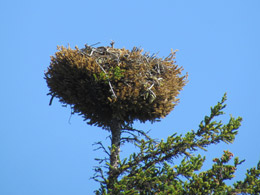
Osprey Nest |
That’s enough facts from Megan. She ended her tour down by the lake where she swam as a kid. She got a little woo-woo and said this place feeds her soul and asked us to name a place that enriches us. Bill mentioned the canyon behind our house. It was the Galapagos for me. For a retiring police officer from New England, it was driving through the Tetons while listening to battle related tunes, all pumped up by 9-11. Our time with Megan and the group was over. It had taken a couple of hours to cover just 3 miles with the group, which put a crimp in plans for a long afternoon hike.
Phelps Lake |
Ranger Megan and Nancy |
We woofed down our peanut butter sandwiches by the lake and dashed back to run through the LPR Visitor’s Center. It’s not like any other Visitor’s Center you’ve seen. There’s no gift shop, no orientation video, no food service – just the latest simple architectural design. The bathroom was so modern I had trouble distinguishing the doors from the walls. (Man, that door was hard to open!) In my practical opinion, the design took up a heck of an area and cost a pretty penny with little payback. One redwood round room just pumped in the sounds of nature. If I wanted sounds of nature, I’d put windows or doors that open onto a deck. In this empty room we kept sitting waiting for something exciting to happen and all we got was sound. Enough of the Visitor’s Center – I must say that Laurence P. Rockefeller did have vision.
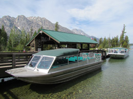
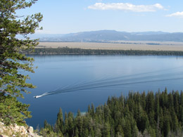
We drove to Jenny Lake. Bill had planned a 9-mile hike to Inspiration Point and Cascade Canyon. I needed refueling so we got ice cream (actually bon bons) and then boarded the ferry to cross Jenny Lake – a very short boat ride, but $10 for round trip.
Jenny Lake |
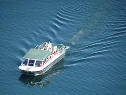
Ferry on Jenny Lake |
We started the hike about 2 p.m. The first mile up to Inspiration Point and the Waterfall were packed with slow old farts making their pilgrimage. After Inspiration Point, the crowd narrowed down to a younger gang – and then further along the trail a large percentage of the hikers spoke in different languages – always the case. I didn’t really enjoy the grandiose vistas at the first of the trail because of the steady stream of hikers.
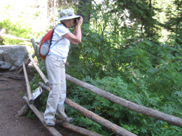
Nancy, inspired at Inspiration Point |
Water Falls |
View of Jenny Lake from the trail |
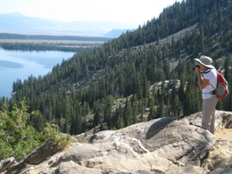
Nancy looking down on Jenny Lake |
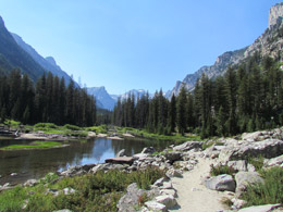
Finally, I took off flying up the mountain. The sugar rush from the bon bons kicked in and my heart started pumping again. I like the physical exertion on a hike almost as much as the views. The trail went up and wrapped around the Tetons. The whole place opened up to a huge river flanked by the high mountain ridges jutting straight up from the river bank.
Cascade Canyon |
Cascade Canyon |
We saw a big moose wading in the river. Another one was close by, but tucked behind a bush. My fabulous new camera with its remarkable zoom got a perfect shot of the beast. What a thrill. My picture-taking session ended when the moose just sat down in the water. But I already had the money shot.
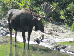
Moose Spotting |
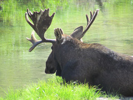
Moose in Cascade Canyon |
Bill and I headed further down the trail, vowing to turn back at 4 pm so we wouldn’t miss the last ferry back to Jenny Lake. I loved that hike along the river and through tall pines. We were hoping to catch a few more moose or maybe even a bear along the way. We turned around at 4:00 with a 4 plus mile hike to get back to the dock. On the way back, another group thought they had spotted a bear across the river. My amazing telephoto camera lens revealed only a tree stump, so we journeyed on. We stopped and saw that same moose still sitting in that same spot in the river. Everyone was hoping he’d get up and do something interesting.
We took a wrong turn on our way back and added some more mileage to our trek. Finally, we got back to the ferry. From the boat, we saw two moose right on the trail where we had been. What a day. We logged over 10 miles of hiking.
We stopped at Trader’s Grill in the Signal Mountain Lodge area for dinner. We had a burger and handcrafted draft beer – hit the spot.
We drove back to our cabin exhausted. I worked on my journal while Bill did the laundry. Tomorrow we head for Yellowstone. The Grand Teton was indeed GRAND!
|